INFORMATION TO VOTERS:
General Election, Tuesday, November 4, 2025
The Excelsior Springs City Council has placed a question on the Tuesday, November 4, 2025, ballot of
whether or not to annex property into the corporate limits of the City.
BALLOT LANGUAGE:
Shall the City of Excelsior Springs, Missouri, annex the following described real property into the
corporate limits of the City?
The real property proposed for annexation consists of the following parcels of land situated in
Clay County, Missouri, each identified by parcel number and abbreviated legal description, and
also identified by its assigned common street address; together with the following described
public rights-of-way:
Property Address: 13915 RHODUS RD: Parcel 12102000300102: BEG NW COR LT 2,
E353.24, SW1257.9, N1218.73 TO POB
Property Address: 23011 NE 140TH ST: Parcel 12102000300100: O’DELL ACRES PT LTS 1
& 2 BEG SW COR LT 1, N66.094, NE1257.9, E959.28, SW1349.34, W TO POB
Property Address: 13719 RHODUS RD: Parcel 12102000301500: BEG 1300’S OF INTERS
RHODUS RD & NE 140TH ST, S367, E750, NE390, W885 TO POB
Property Address: 13623 RHODUS RD: Parcel 12102000301400: BEG 20’W OF SW COR
SEC, NLY970, E750.32, SWLY ALNG ROW 996.1, W462.7 TO POB
Property Address: RHODUS RD: Parcel 12104000200800: EG 25’W OF NW COR SEC, E380 TO WL RR, SLY 280, W375 TO EL RD, NLY ALNG EL RD TO POB
Property Address: 13517 RHODUS RD: Parcel 12104000200700: BEG 275’S & 80’W OF NW
COR SEC E375 TO WL RR, SLY1188.15, W210 TO EL RD, NLY ALNG RD TO POB
Property Address: 13300 RHODUS RD: Parcel 12104000200500: BEG 40’W OF W1/4 COR
SEC, NLY ALNG EL RD 1210, E210 TO WL RR, SLY1188, W185 TO POB
Property Address: 13300 RHODUS RD: Parcel 12104000200401: TRACKS IN SECTION 8
NOT IN MOSBY
Parcel ID: 12102000300200: RAILROAD ROW LOCATED IN SEC 5 TWP 52 RANGE 30 S
OF THE N ROW LINE OF 140 TH ST
Property Address: 13511 RHODUS RD: Parcel 12104000200600: W1/2 NW1/4 LYING E OF
RR
Property Address: 13603 RHODUS RD: Parcel 12102000301200: BEG NE COR SE1/4 SW1/4,
S992.7, W330, S330, W988.2, N347.4, NE266.6, NLY801.6, E1134.6 TO POB
Property Address: CAMERON RD: Parcel 12104000200101: BEG N1/4 COR SEC, S TO NL
LT 1 RHODUS FARMS, W340, S1370, W950, N1648.1, E1320 TO POB
Property Address: 13606 CAMERON RD: Parcel 12102000301100: BEG SW COR SW1/4
SE1/4, E330.6, N330.6, E1617.3, S330.6, W1610 TO POB
Property Address: 13586 CAMERON RD: Parcel 12104000200103: BEG N1/4 COR SEC, E
TO WL LT 1 RHODUS FARMS, SWLY ALNG NL LT 1 TO WL NE1/4, N TO POB
Property Address: 13526 CAMERON RD: Parcel 12104000200104: RHODUS FARMS
REPLAT LT 1 LT 1A
Property Address: 13611 RHODUS RD: Parcel 12102000301300: BEG SE COR SW1/4 SW1/4,
N347.4, NE266.6, NLY801.6, W496.7, SWLY6.7, SLY ALNG RR ROW 1385, E773.9 TO
POB
Property Address: 23401 NE 140TH ST: Parcel 12102000300300: BEG SE COR NE1/4 SW1/4,
N1040, W150, N265.4, W1040, SW1360, E1640 TO POB
Property Address: 23425 NE 140TH ST: Parcel 12102000300400: BEG 25’S OF NE COR
SW1/4, S 265.4, W150, N265.4, E150 TO POB
Property Address: 23675 NE 140TH ST: Parcel 12102000300501: BEG NW COR LT 1 WEST
SPRINGS, S690, W900, N700, E900 TO POB
Property Address: 13919 CAMERON RD: Parcel 12102000300600: WEST SPRINGS LT 1
Property Address: 13906 CAMERON RD: Parcel 12102000300700: WEST SPRINGS LT 2
Property Address: 13818 CAMERON RD: Parcel 12102000300800: WEST SPRINGS LT 3
Property Address: 13804 CAMERON RD: Parcel 12102000300900: WEST SPRINGS LT 4
Property Address: 23619 NE 140TH ST: Parcel 12102000300500: BEG SW COR LT 4 WEST
SPRINGS, W890, N655, E900, S665 TO POB
Property Address: 13716 CAMERON RD: Parcel 12102000301000: CAMERON ROAD
ESTATES LT 1
Property Address: 13624 CAMERON RD: Parcel 12102000301001: CAMERON ROAD
ESTATES LT 2
Property Address: 25819 NE 136TH STREET: Parcel 12203000100104: Ballew Minor Lot 1
Property Address: 25807 NE 136TH STREET: Parcel 12203000100103: Ballew Minor Lot 2
Property Address: 25801 NE 136TH STREET: Parcel 12203000100102: Ballew Minor Lot 3
Property Address: 25615 NE 136TH ST: Parcel 12203000100105: BEG 700’S OF NW COR
NE1/4 NE1/4, S564.4, E300, NE460, W300, N670, W45 to POB
Property Address: 25613 NE 136TH STREET: Parcel 12203000100200: BEG 25’S OF NW
COR E1/2 NE1/4, E300,S265.4, W300, N265.4 to POB
Property Address: 25611 NE 136TH STREET: Parcel 12202000100300: BEG 290.4’S OF NW
COR E1/2 NE1/4, E300, S145.2, W300, N145.2 to POB
Property Address: 25609 NE 136TH STREET: Parcel 12203000100101: TR A (H-138)
Property Address: NE 136TH ST: Parcel 12203000100111: TR B (H-138)
Property Address: 25021 NE 136TH STREET: Parcel 12203000100400: BEG SL NE 136th St
& EL W1/2 NE1/4, S2640, W to CRK, NLY ALNG CRK TO NL S1/2 SW 1/4 SE 1/4 NW 1/4,
W TO WL SE 1/4 NW1/4, W TO WL SE 1/4 NW1/4, N1940, W368.94, NWLY471.4 ELY TO
POB
Property Address: N 69 HWY: Parcel 12203000100401: S1/2 SW1/4 SE1/4 NW1/4 LYING W
OF CRK
Property Address: NE 136TH ST: Parcel 12203000100900: BEG NE COR W1/2 SE1/4, WLY
ALNG CREEK TO NL S1/2 SEC, E2280 TO POB
Property Address: 24609 NE 136TH TER: Parcel 12201000501500: BEG 735’E OF SW COR
SEC, E570, N570, N295, W685, SELY 302.8 TO POB EXC PT IN ROW AND EXC THAT
PART N OF NE 136 th STREET
Property Address: 24421 NE 136TH TER: Parcel 12201000501400: BEG SW COR SEC, W TO
EL SCOTT ACRES, NE TO SL NE 136TH TERR, E ALNG ROW 630, SE TO SL SEC, W TO
POB
Property Address: 24225 NE 136TH TER: Parcel 12203000100500: BEG NW COR SEC, E750
SELY471.4, E368.94, S909.43, W TO WL SEC N905, W TO EL SCOTT ACRES, NE ALNG
EL SCOTT ACRES TO POB
Property Address: 24217 NE 136TH TER: Parcel 12102000401400: SCOTT ACRES PT LT 1
LYING IN 5-52-30
Property Address: 24217 NE 136TH TER: Parcel 12104000100100: SCOTT ACRES PT LT 1
LYING IN 8-52-30
Property Address: 24205 NE 136TH TER: Parcel 12102000401500: ROSE ACRES 2ND PLAT
LT 1
Property Address: 13601 CAMERON RD: Parcel 12102000401700: ROSE ACRES LT 1
Property Address: 13425 CAMERON RD: Parcel 12104000100300: BEG 430’S OF NE COR
SEC, W323.06, N328, N968.13, S1240, E1300, N905
Right-of-Way Annexation Description
Beginning at the point where the northerly right-of-way line of NE 136th Street intersects the
existing City Limits of the City of Excelsior Springs, Missouri, said point being located in the
Northwest Quarter of Section 4, Township 52 North, Range 30 West, Clay County, Missouri,
and also adjacent to the Northeast Quarter of Section 9, Township 52 North, Range 30 West;
thence westerly along both the northerly and southerly right-of-way lines of NE 136th Street, and
continuing along NE 136th Terrace where said roadway turns, encompassing the full width of
said public right-of-way, to the point of intersection with the right-of-way of Cameron Road;
thence northerly along both the easterly and westerly right-of-way lines of Cameron Road,
encompassing the full width of said public right-of-way, to the point of intersection with the
northerly right-of-way line of NE 140th Street;
thence westerly along both the northerly and southerly right-of-way lines of NE 140th Street,
encompassing the full width of said public right-of-way, to the point of intersection with the
westerly right-of-way line of Rhodus Road;
thence southerly along both the westerly and easterly right-of-way lines of Rhodus Road,
encompassing the full width of said public right-of-way, to the point of intersection with the
northerly right-of-way line of NE 134th Street;
returning to the intersection of NE 136th Terrace and Cameron Road, thence southerly along the
easterly and westerly right-of-way lines of Cameron Road, encompassing the full width of the
existing right-of-way, to a point of termination at its intersection with a line projected westerly
from the northern boundary of the existing City Limits of the City of Excelsior Springs,
Missouri,
excluding from this description any portion of said Cameron Road right-of-way that lies within
the corporate boundaries of the City of Mosby, Missouri;
said annexation to include the entire widths of the public rights-of-way of NE 136th Street, NE
136th Terrace, NE 140th Street, Cameron Road (as limited above), and Rhodus Road, as
described above.
☐ YES
☐ NO
If a majority of the votes cast on the question by the qualified voters voting thereon are in favor of the
question, then the City of Excelsior Springs shall be authorized to annex the property described herein
into the corporate limits of the City.
MAP OF ANNEXATION AREA
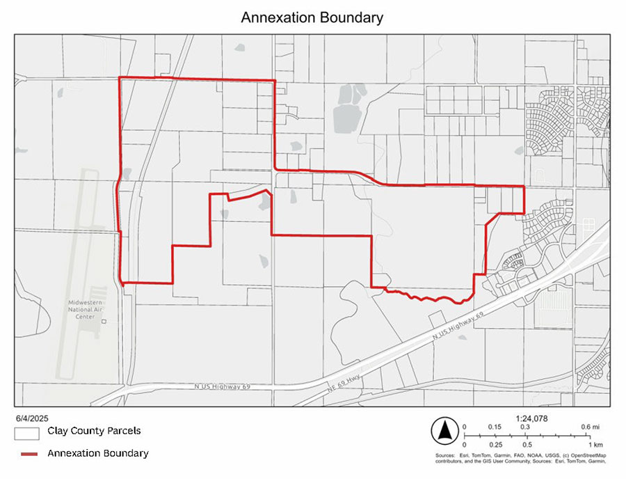
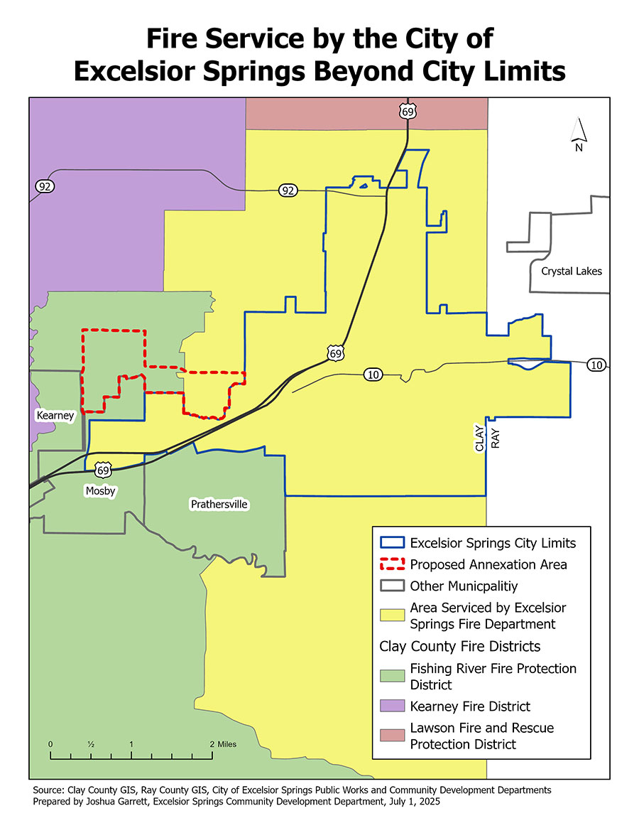
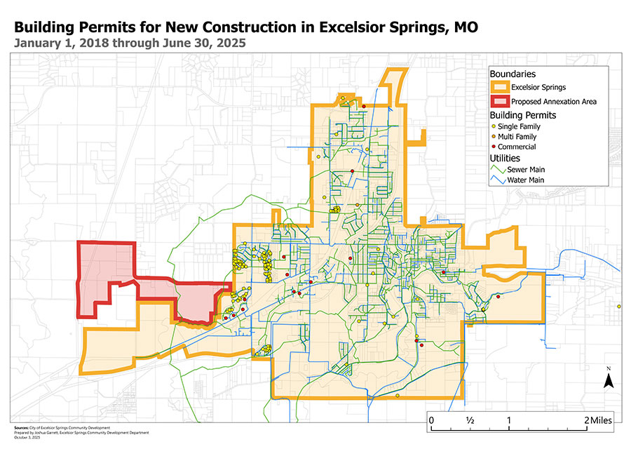
BACKGROUND
On June 5, 2025, the City Council of Excelsior Springs adopted Ordinance No. 25-06-03, calling for an
election on November 4, 2025, to submit to the registered voters of the City the question of annexing
certain adjacent territory, including your property, into the City limits. This action is taken pursuant to
Section 77.020 RSMo, which allows third-class cities like Excelsior Springs to extend their boundaries
with the approval of a majority of voters within the existing city limits.
The City Council believes that annexing this area would promote the orderly growth and development of
our community, enable more efficient provision of municipal services, and support the long-term
planning objectives of the City. The City also believes that annexation will provide a timely and practical
response to increasing development pressures in the area. By incorporating this territory into the City
limits, Excelsior Springs will be better positioned to offer more responsive governance, ensure
consistent application of land use regulations, and protect the long-term interests of current and future
residents. Moreover, the area proposed for annexation lies within the City’s logical growth pattern. Its
proximity to existing development and infrastructure makes it well-suited for future integration into the
City’s.
VOTER REGISTRATION INFORMATION
CLAY COUNTY: https://www.voteclaycountymo.gov/voter-registration
RAY COUNTY: https://raycountymo.com/index.php/ray-county-clerk/
Information Provided and Paid for by City of Excelsior Springs.
201 E Broadway, Excelsior Springs, MO 64024
City Manager Molly McGovern